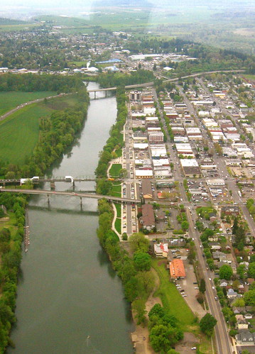
This is an aerial shot of Corvallis facing south--it's only a small sliver of the city. In the image, you can see most of downtown and Southtown, as well as the floodplain across the river from downtown. The river that runs through our city is the Willamette. The three bridges, going southwards (upwards in the picture), are the Harrison St bridge, the Van Buren Bridge, and at the top of the picture, the Peoria Bypass Bridge. If you look just past the top bridge, you can see where the river bends; I'm playing soccer at a park there this morning. My house is to the west (the left side) of the picture--you can't see where I live on this photo as Corvallis basically spreads westwards and northwards from this point. I'll try and see if I can get some photos whilst I'm out. You also cannot see Oregon State University's campus in this photo; it is directly west of downtown.